Research and Monitoring Priorities
I. NERRS Science Collaborative Priorities for Lake Superior, 2022
Chapter 4: Research and Monitoring Activities
This section covers information on research and monitoring activities within the Reserve.
While the Reserve addresses overarching research and monitoring priorities in each 5-year management plan, staff produce research priorities for the annual NERRS Science Collaborative competition and the bi-annual NOAA Davidson Fellowship competition. These focused articulations of research needs are drawn from needs of partners and the Reserve and represent potential opportunities for collaboration.
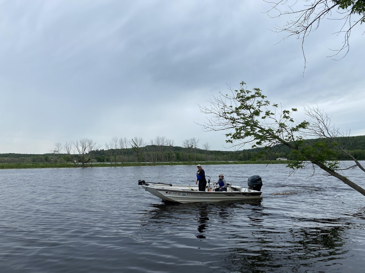
Figure 1: Reserve researchers travel through the upper estuary on the RD Browne, the Reserve’s vessel specialized for shallow water. Credit: Deanna Erickson, Lake Superior Reserve.
Research Priorities:
- Habitat resilience: The invasive emerald ash borer has begun to impact black ash-dominated forested wetlands in the St. Louis River estuary and will likely cause shifts in species composition and wetland function but the ecological impacts in a Lake Superior estuarine environment is unknown, especially in the context of daily, seasonal and long term water level fluctuations and increasing flood events, therefore robust analysis of the extent and ecological function of these forested wetlands in Lake Superior estuaries may help inform future restoration and management efforts.
- Climate change: Through protection, remediation and restoration efforts, the St. Louis River estuary is overcoming a legacy of contamination, however, a lack of suitable spatial and temporal water quality data inhibits the ability to understand how flood events and other climate change stressors may impact the long-term health of the estuary. Therefore, additional research that elucidates past and current sediment and nutrient dynamics is needed to identify future monitoring needs and tools that will help the Reserve strengthen partner and community restoration and resilience efforts.
- Lake Superior has recently been experiencing blue-green algae blooms and there is concern about the potential for these blooms to cause harm to human and biotic communities, but the mechanisms driving these events are only beginning to be understood. Therefore, developing the methodologies to better understand the role the St. Louis River estuary and other tributaries play in influencing regional blooms may provide crucial tools for future management.
- The St. Louis River is transitioning from remediation of legacy contaminants and restoration to future wholistic planning for long term resilience but overall estuarine ecological function post-restoration is largely unknown and comprehensive planning does not yet exist beyond the framework of the St. Louis River Area of Concern. Therefore the application of a landscape conservation design process can provide the expertise, structure and long-range vision for a healthy estuary and a model for other NERRS in the system.
- High water levels have persisted in Lake Superior over the past four years and this has created extreme conditions for wetland and plant communities as well as waterfront infrastructure but planners, resource managers and property owners need to make decisions and investments that consider periodic oscillations in water levels. Therefore additional information about feasible adaptive coastal management practices that consider fluctuating extremes in water levels is needed.
II. Margaret A. Davidson Graduate Fellowship Priorities for 2022
- The invasive emerald ash borer has begun to impact black ash-dominated forested wetlands in the St. Louis River estuary and will likely cause shifts in species composition and wetland function but the ecological impacts in a Lake Superior estuarine environment is unknown, especially in the context of daily, seasonal and long term water level fluctuations and increasing flood events, therefore robust analysis of the extent and ecological function of these forested wetlands in Lake Superior estuaries may help inform future restoration and management efforts.
- Decision-makers are concerned about meeting community needs when implementing St. Louis River estuary restoration and conservation projects, and value community input as a critical component of successful projects but seek guidance on how to authentically and effectively engage diverse users of the landscape when restoration projects arise. Therefore, local decision-makers would benefit from place-grounded inquiry that builds robust community engagement processes into project outcomes, culminating in recommendations and/or applied tools that can guide engagement efforts in the future.
- Through protection, remediation and restoration efforts, the St. Louis River estuary is overcoming a legacy of contamination, however, a lack of suitable spatial and temporal water quality data inhibits the ability to understand how flood events and other climate change stressors may impact the long-term health of the estuary. Therefore, additional research that elucidates past and current sediment and nutrient dynamics is needed to identify future monitoring needs and tools that will help the Reserve strengthen partner and community restoration and resilience efforts.
- Flood events and high-water levels over the past decade have severely impacted regional communities and observing the impacts of these changes on the Lake Superior coast can motivate decision makers to prioritize resilience but the impacts and benefits of resilient coastal infrastructure solutions are not always clear to communities considering their implementation. Therefore, assessments of targeted policy or engineering options would help Lake Superior coastal communities understand how to take action in the context of increasing flood events and fluctuating water levels.
- Western Lake Superior is experiencing more precipitation, warmer winters and increasing storm events and these environmental changes impact human health and well-being in complex ways but the myriad of impacts of climate change on place-based seasonal recreation and subsistence activities in communities surrounding Lake Superior estuaries is not well understood. Therefore, an analysis of the local impacts of climate change on individual and community well-being and identity related to these activities may help inform adaptation strategies, plan for transitions and integrate future recreation and subsistence needs in land management decisions.
Guidance for Appropriate Engagement with Reserve Communities
I. Complex Context: a river that unites jurisdictions
The Lake Superior National Estuarine Research Reserve and the estuary at the mouth of the St. Louis River is within the jurisdiction of multiple governments and complex social contexts. The estuary is nested within the United States and the 1842 and 1854 Ceded Territories of the Anishinaabe Ojibwe. The line dividing Wisconsin from Minnesota runs down the center of the estuary, and research and restoration frequently occur through bi-state coordination. Finally, the estuary bridges the cities of Duluth in Minnesota’s St. Louis County and Superior in Douglas County, Wisconsin. Upriver from the estuary, the river borders the Fond du Lac Band of Lake Superior Ojibwe (Chippewa) reservation and the Minnesota cities of Carlton and Cloquet in Carlton County.
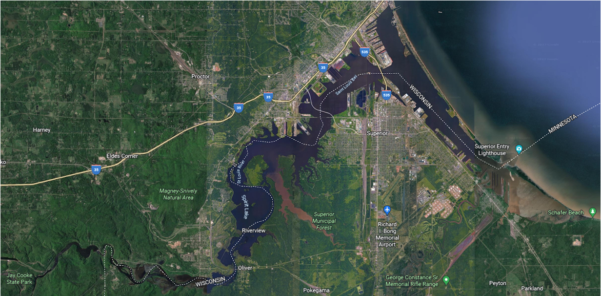
Figure 2: Multiple jurisdictions overlap in the St. Louis River estuary. Credit: Google Earth.
This multijurisdictional setting means that appropriate engagement often requires considerable advance planning to ensure that governments and communities are informed and well coordinated as research projects and programs take place. Both formal consultation and meaningful informal engagement improve research and restoration efforts.
This overview is subject to change without being updated here and may require additional consultation that is not listed. Please consult the Reserve as well as Tribal, Federal, State and local governments and agencies to confirm up to date requirements and processes.
II. Community Engagement and Environmental Justice
The Lake Superior Reserve is a partner in the Lake Superior Headwaters Sustainability Partnership (Headwaters Partnership). As established by planning partners, Headwaters Partnership creates an inclusive and intentional framework for how and where partners work to achieve a thriving estuary landscape and community. The principles of sustainability, resiliency, and equity guide this collective approach to managing lands and waters by including economic development, community health and well-being considerations.
In 2022, a Headwaters Partnership collaborators developed goals and objectives for twelve priority concerns for the Headwaters Partnership. These include priorities related to both community engagement and environmental justice meant to inform all research, conservation and restoration actions in the estuary. A full overview of the goals and objectives of each of these priority concerns is available at this link, but the overarching goals include:
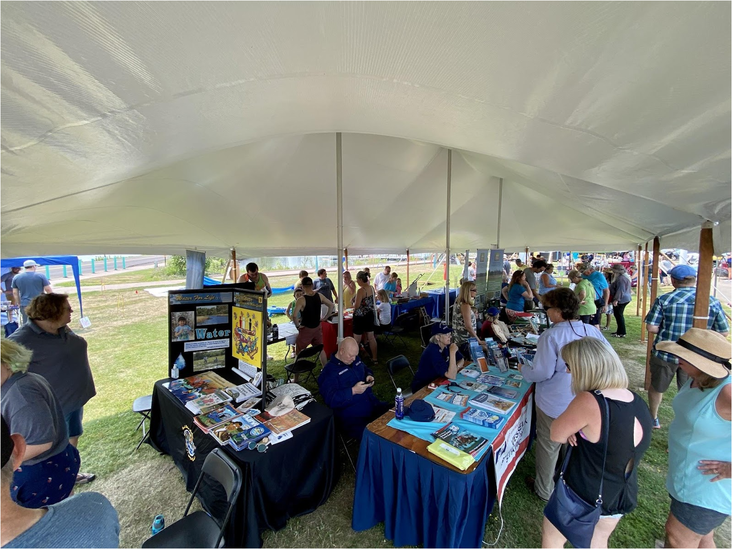
Figure 3: The Reserve frequently engages with community members through events such as the annual Lake Superior Day on Barkers Island each July. Photo credit: Deanna Erickson, Lake Superior Reserve.
Headwaters Partnership Community Engagement Goal
Community engagement is prioritized and valued as essential to support a thriving social-ecological system in the lower St. Louis River. Communities connected to the river generate, inform, co-develop, contribute to, and evaluate the actions of the Headwaters Partnership, with reciprocal responsiveness, resources, and support from the Partnership.
Headwaters Partnership Environmental Justice Goal
Outcomes of the Headwaters Partnership advance the multiple dimensions of environmental justice through protection and restoration of the St. Louis River estuary ecosystems, equitable and sustainable revitalization of estuary communities, and promotion of reciprocal relationships between humans and nature.
Prior to developing a research plan, work with Reserve staff and partners to establish a meaningful community engagement process and build consideration of environmental justice concerns into research design and outcomes. For example, if a research project will conduct work near a neighborhood, consider discussing the work with community groups or interested individuals in that neighborhood to gather input on important questions they may have, plan your research to address their concerns and interests, and determine the best way to share your results. Reserve and partner staff can support this effort.
For more on considering engagement while planning research, consult the Guide to Collaborative Science developed by the NERRS Science Collaborative.
III. Anishinaabe Ceded Territory Requirements and Practices
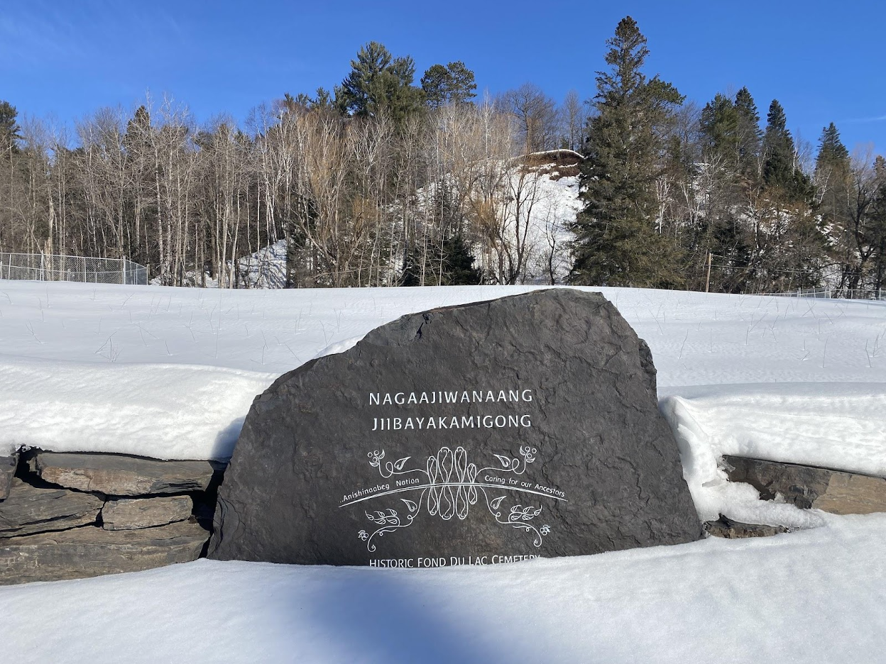
Figure 4: The Nagaajiwanaang Jiibayakamigong memorial near the St. Louis River in the Fond du Lac neighborhood of Duluth commemorates Anishinaabe burials that were disinterred by highway construction in 2017, after consultation with Tribal Nations was neglected. The site had been heavily impacted in the past and is a reminder of the importance of early and thorough consultation when disturbing ground, even in places of previous disturbance.
Cultural connections and legacy are given continuity by the presence of important historic sites in the estuary. If these sites are disturbed or lost, that legacy cannot be fully transmitted. Any projects within the Reserve or the St. Louis River estuary that could cause disturbance to cultural sites or artifacts are reviewed by the Fond du Lac Band of Lake Superior Ojibwe (Chippewa) Tribal Historic Preservation Officer, whose Ceded Territory the estuary is in, as well as other Tribal Nations that have a traditional presence in the region. Because the estuary has been a cultural corridor for centuries, projects that may disturb a site typically require THPO review to ensure protection. Remember that water levels have fluctuated through time, and sites or artifacts may be underneath the water.
In instances where federal funding is used in all or part of the work, this consultation with federally recognized Tribal Nations is mandated and may be supported in part by NOAA. In these instances, a letter describing the project is issued following an overview meeting. Fond du Lac, other Tribal Nations, or the State Historic Preservation Officer (in Wisconsin or Minnesota) may choose to respond to the letter within a set period of time, typically 30 days. Best practice is to have an informal discussion with tribal representatives prior to planning your work if it may involve site disturbance. Work with staff at the Lake Superior Reserve to begin these discussions and the review process well in advance. Recognize that plans may change in response to review.
IV. Federal Requirements
National Environmental Protection Act (NEPA)
“The National Environmental Policy Act (NEPA) of 1969 is the foundation of modern American environmental protection in the United States and its commonwealths, territories, and possessions. NEPA requires federal agencies to carefully consider the impacts of their proposed actions on the environment, involve and inform the public in the decision making process, and incorporate these considerations in implementing the decision. NEPA established the Council on Environmental Quality (CEQ) to act in an advisory capacity for the President on environmental matters. CEQ established regulations to assist federal agencies in implementing NEPA. These regulations, along with specific federal agency NEPA implementation procedures, ensure that the environmental impacts of proposed decisions are fully considered, the public has opportunities for input, and that appropriate steps are taken to mitigate potential environmental impacts.” - NOAA Fisheries, April 15, 2022
Any research or restoration efforts that are funded, assisted, regulated, conducted, approved, or permitted by a federal agency are subject to NEPA review. In the National Estuarine Research Reserve System, NEPA review is conducted by NOAA environmental compliance staff. After clear and accurate descriptions of activities have been provided, NEPA review generally results in the work being assigned to one of the following methods of documentation:
Categorical Exclusion: Used when environmental impacts are well documented to have no potential to be significant; AND “Extraordinary circumstances” are not present
Environmental Assessments: Used when “categorical exclusion” does not apply OR if extraordinary circumstances exist. This assessment helps NOAA determine if the environmental effects will be significant.
Environmental Impact Statements: Used when environmental effects are expected to be significant, for example in the designation of a new National Estuarine Research Reserve.
Work with your funding agency to determine if NEPA applies to your work, or reach out to Reserve staff if you believe review may be required.
Endangered and Threatened Species
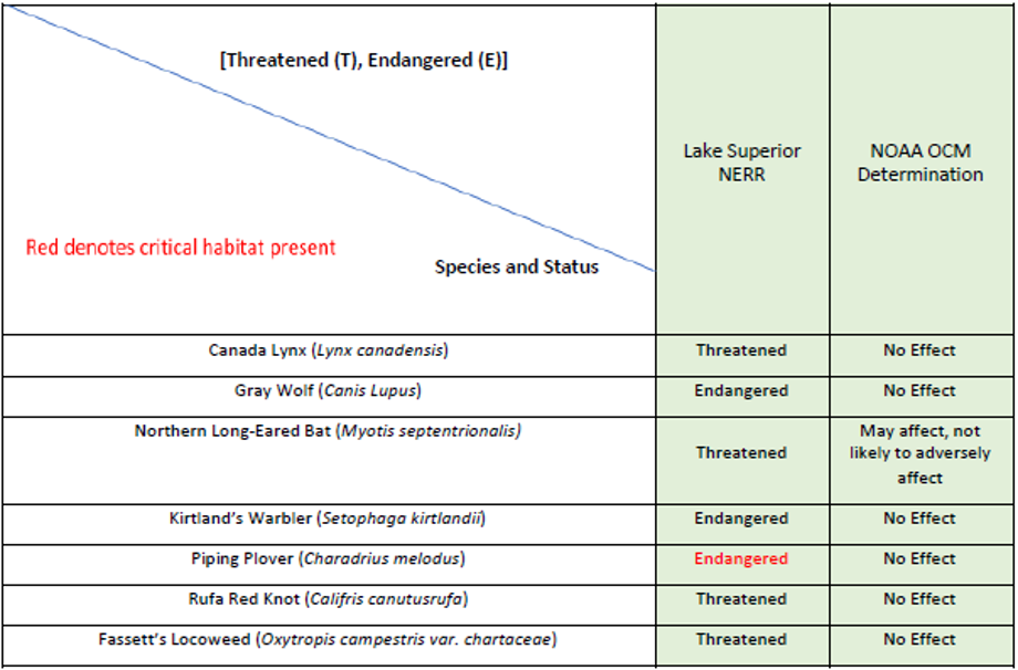
Figure 5: ESA-listed species found in the Lake Superior Estuarine Reserve Area (Douglas County, WI/Saint Louis County, MN) Source: Lake Superior NERR Threatened and Endangered Species Programmatic Coverage, Jennifer Ballinger, 2020.
Research, restoration and construction activities have the potential to disturb endangered or threatened species. As a NOAA-led program, the Reserve works with the federal government to ensure that this does not occur. Research or other projects that take place in the estuary may be subject to review under the Endangered Species Act (ESA). The Reserve has programmatic coverage for certain activities. Discuss your project or research plans with the Reserve Director to determine if Endangered Species Act review may be required.
Text below adapted from the Lake Superior NERR Threatened and Endangered Species Programmatic Coverage, Jennifer Ballinger, 2020.
NOAA’s Office for Coastal Management (OCM) implements and provides technical assistance related to the decisions and actions taken to keep the natural environment, built environment, quality of life, and economic prosperity of our coastal areas in balance. The Coastal Zone Management Act is the guiding legislation while the University of Wisconsin- Madison Division of Extension (Extension) administers the Lake Superior National Estuarine Research Reserve, as approved by NOAA. NOAAs OCM Stewardship Division provides federal funds, in the form of cooperative agreements such as grants, for projects related to the state’s coastal management program and the National Estuarine Research Reserves. These projects include, but are not limited to, planning; outreach; climate change and water quality monitoring; fish assemblage research projects; invasive species stewardship, including control and/or removal of invasive species; and small-scale construction projects (e.g.; construction, replacement and repair of access ways and trails). NOAA provides financial resources and technical assistance to state agencies for construction, maintenance, and operations related to the nation's coastal resources. Prior to funding and authorizing any project that NOAA receives through their grant application program, OCM must complete its own project review and may be required to engage in ESA consultations on projects that may affect listed species or designated critical habitat. Generally, review of the grant projects results in a determination that the project will have no effect or is not likely to adversely affect listed species, and the ESA Section 7 Consultation for these projects remains informal. The purpose of this Programmatic ESA Consultation is to simplify reviews of such routine, non-controversial projects with minimal impacts in the Lake Superior NERR region, allowing project planning to occur with greater efficiency.
- Habitat restoration and conservation
- Biological and Vegetative Monitoring
- Water Quality and Nutrient-Level Monitoring
- Weather and Climate Monitoring
- Stewardship, Habitat Conservation, and Invasive Species Control
- Accessibility and Facilities Management
- Education and Outreach Programs
These activities were selected and analyzed in a Programmatic Endangered Species Act review by NOAA because they frequently occur throughout the Reserve sites. Projects that do not fit into the described activity types are not covered by the Programmatic ESA and will be subject to ESA Section 7 Consultation on an individual basis.
V. State Requirements
Wisconsin Endangered Resources Review
“An Endangered Resources Review (ER Review) is a screening of a proposed project area for potential impacts to endangered resources like rare plants, animals and natural communities. They are conducted for a wide variety of land management, development and planning projects. A general rule of thumb is any land or water-disturbing project should be reviewed for impacts on rare species.” - Wisconsin Department of Natural Resources
Research, monitoring and restoration activities may not need review if they are considered no or low impact. For other projects, you must submit an endangered resources review request. Note that the review costs $75 per hour of DNR staff time to review the project, with a minimum cost of $75. Standard time for review is 10 business days. To get a review, visit the Wisconsin DNR endangered resources review page at: https://dnr.wisconsin.gov/topic/erreview/review.html
VI. County and City Approvals
The City of Superior and Douglas County both have standing committees that review environmental restoration and research actions on their respective properties. For details on City of Superior processes, reach out to the Parks, Recreation and Forestry Director at (715) 395-7270. For details on review and approval processes in Douglas County, contact the land conservation office at (715) 395-1380 or the Forestry and Natural Resources Director at (715) 395-7270 .
Relevant boards and committees in the City of Superior that may review or approve a project include:
- The Wisconsin Point Committee
- Parks and Recreation Commission
- Urban Forestry Tree Board
- Superior City Council
Relevant boards and committees in Douglas County that may review or approve a project include:
- Land and Development
- Land Conservation
- Forest, Parks and Recreation
- Douglas County Board of Supervisors
The Reserve staff will provide support if your project requires city and county review. Please do not reach out to city and county officials without speaking with Reserve staff members first.
Research and Monitoring Activities (past and current)
The Reserve has worked on a broad range of research and monitoring projects to address the most pressing science and management needs in the region. This work is often done in partnership with land managers and Tribes, and is used to inform and enhance the other sector programs at the Reserve.
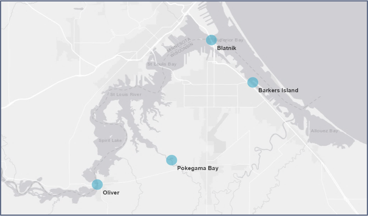
Figure 6: The Lake Superior Reserve has four system-wide monitoring stations, shown above as blue dots. Image credit: Hannah Ramage, Lake Superior Reserve.
I. Monitoring
- System-Wide Monitoring Program (SWMP): Research staff are responsible for operating the Reserve’s System-Wide Monitoring Program (SWMP) and Sentinel Site program. SWMP provides researchers, resource managers, educators and other coastal decision makers a standardized network of data sondes and sampling/monitoring measures. We initiated SWMP in 2012, and it is comprised of 4 water quality monitoring stations throughout the estuary and one meteorological station.
- Sentinel Site Application Module 1 (SSAM-1): The first sentinel site application module (SSAM-1) developed for the National Estuarine Research Reserve System’s SWMP data is focused on understanding changes in sea levels, inundation, and the associated responses of marsh, mangrove, and submerged aquatic vegetation. This focus could be expanded to include ecologically important transition zones that are characterized by scrub-shrub and coastal maritime forest. Eventually, Sentinel Site will link a wide array of NOAA meteorological stations all over the country with SWMP stations and other Reserve monitoring projects to evaluate how coastal ecosystems are responding to climate change.
- Adaptive restoration in black ash wetlands of the St. Louis River Estuary: This project conducts rapid response restoration in emerald ash borer (EAB) impacted black ash coastal wetlands by removing invasive plants, primarily non-native buckthorn (Rhamnus cathartica & Frangula alnus) and non-native honeysuckle (Lonicera spp.) and planting and protecting native tree seedlings selected for the dynamic estuarine hydrologic conditions found along Lake Superior. With the detection of EAB near the Superior Harbor in 2013, the impacts of EAB have been increasingly detected in the upper St. Louis River estuary, making this project a high priority to sustain ecosystem services and prevent coastal erosion. The request covers four years of the project- removal of invasive plants in the first year, followed by tree seedling planting the following summer, with monitoring, tree planting and treatment maintenance the following two years. Monitoring of survival and growth by the Lake Superior NERR will continue beyond the funding period, for the purpose of providing management recommendations to other estuarine ash-dominated wetland sites along the Lake Superior coast in Wisconsin, where similar geologic and hydrologic conditions exist.
II. Research
Current Projects (Updated June 2023)
- Building a collaborative water quality monitoring strategy for a changing St. Louis River Estuary: After a history of contamination, the St. Louis River Estuary is being revitalized through protection, remediation, and restoration, but simultaneously faces pressing new water quality challenges. Recent shifts in algal communities, harmful algal blooms, and hypoxia in estuary “hotspots” are not well understood, leaving water stewards without critical information needed to respond. This project conducts foundational research to quantify and characterize the nutrient dynamics that lead to degraded algal communities, toxic cyanobacterial blooms, and hypoxia in the estuary. Our diverse network of organizations is building a collaborative monitoring strategy to address current and future stressors. This project will support that effort through the following: (1) a synthesis of known nutrient and algal dynamics; (2) an easily interpreted data access platform; (3) a recommendation report that specifies the location, timing, and parameters needed for a feasible and effective long-term monitoring program; and targeted (4) local and (5) national communications. The approaching delisting of the Area of Concern (AOC) creates a timely need to transition water quality monitoring efforts from “looking back” to “looking forward.” This project ensures that already engaged end-users work from a shared understanding to build a collaborative monitoring strategy that protects the restored health of the estuary.
- Emerald Ash Borer: This work is focused on continuing work conducted by Nicholas Bolton at Michigan Technological University in 2015-2017 which evaluated the survival of different tree species that had potential for replacing ash trees being killed by the Emerald Ash Borer. The treatments in this project included herbivore repellants, elevation differences, varied planting techniques, and other factors. We are returning to these sites in 2021 to evaluate survival of different species and efficacy of different treatments.
- HiTIDER: The aim of the History and Topography to Improve Decision-making for Estuary Restoration (HiTIDER) Project is detecting estuarine habitat loss and opportunities for future restoration in and around National Estuarine Research Reserves. This project is funded through the National Estuarine Research Reserve System Science Collaborative and employs historical and elevation-based mapping to describe the past, current, and future condition of major estuaries across the US.
Past Projects
- Testing biological controls on purple loosestrife: In recent years, the Reserve conducted plant cover surveys to assess long-term changes in purple loosestrife abundance in areas where galerucella spp. beetles were introduced. On top of assessing loosestrife abundance, we wanted to know whether the introduced beetles were actually useful in controlling the species. To do that, we conducted an exclusion experiment—we built mesh-covered cages around some purple loosestrife plants that allowed them to grow but kept the beetles out. This allowed us to gauge any growth differences between loosestrife that is accessible to the beatles and loosestrife that is not. Our surveys showed that purple loosestrife remains in relatively low and controllable abundance in the study area, and that the beetles likely contribute to controlling the invasive species. We are continuing to monitor purple loosestrife within the Reserve and how the leaf-skeletonizing beetles affect it.
- Rusty Crayfish population increase and spread: Like many Wisconsin and Minnesota waterways, the St. Louis River Estuary is home to the invasive rusty crayfish, which was first documented here in 1999. One of our past research projects is documenting the rusty crayfish population in the estuary, as well as the populations of native crayfish. Our research has shown that populations of all crayfish in the estuary, including rusty crayfish, have plummeted since 1999.
- Under-ice water quality: In the winters of 2013 - 2016, we have drilled through ice in locations throughout the estuary to measure water quality parameters like dissolved oxygen and turbidity. Our goal is to document how water quality changes in the winter, and how it is affected by vastly different water sources like Lake Superior and the clay-bottomed Pokegama River. These data could help us understand how winter conditions might influence water quality throughout the year and how climate change might affect water quality.
Publications and Online Bibliography
All works cited or consulted in the creation of this site profile are listed in our online bibliography, hosted by Zotero. Zotero is a free, open-source reference management software that allows users to collect, organize, and store reference materials in online libraries. Our online bibliography can be accessed through this link: https://www.zotero.org/groups/3740017/lsnerr_site_profile_bibliography/library
No account or subscription is required to see the items stored in a Zotero library.