Lake Superior NERR Logo

Lake Superior National Estuarine Research Reserve Site Profile

Administrative Overview

I. Mission, Site Description, Inclusive of Human Dimensions, & Lead Agency Info

Mission

The Reserve works in partnership to improve the understanding of Lake Superior’s coast and estuaries. We address issues affecting the watershed through the integration of research, education, outreach, and stewardship.

Chapter 1: Reserve Introduction

This section covers administrative information, an introduction to the Reserve and an overview of the Estuary.


Interactive elements to explore include:
- An Overview of Reserve Research Priorities
- An Interactive Reserve Habitat Map

Vision

Lake Superior coastal watersheds and estuaries are understood, valued, and thriving.

Site Overview

The Lake Superior National Estuarine Research Reserve encompasses over 16,000 acres along the St. Louis River freshwater estuary in Wisconsin. The Reserve is part of the University of Wisconsin–Madison Division of Extension’s Natural Resources Institute with leadership from the National Oceanic and Atmospheric Administration and is based on the University of Wisconsin-Superior campus in the City of Superior.

The Lake Superior Reserve is one of only two estuarine reserves in the Reserve System located on the Great Lakes. This makes the research we and our partners conduct all the more vital to the understanding of freshwater resources and the health of the Great Lakes, which hold more than 20 percent of the Earth’s surface freshwater.

Management Plan Available here.

A map depicting the locations of the 29 National Estuarine Research Reserves

Figure 1: A map depicting the locations of the 29 National Estuarine Research Reserves.

A map depicting the extent of the St. Louis River watershed.

Figure 2: A map depicting the extent of the St. Louis River watershed.

The Reserve is centered on the St. Louis River Estuary between Superior, Wisconsin, and Duluth, Minnesota. However, we envision a Lake Superior where all coastal watersheds and estuaries are understood, valued and thriving. To accomplish this, we prioritize work on climate change, water quality, healthy ecosystems, strengthening communities, and developing a sense of place.

Lead Agency Information

A graphic of the logos for each lead agency affiliate

Figure 3: Lead agencies affiliated with the Lake Superior Reserve

The Lake Superior National Estuarine Research Reserve encompasses over 16,000 acres along the St. Louis River estuary in Wisconsin. The Reserve is part of the University of Wisconsin–Madison Division of Extension’s Natural Resources Institute with leadership from the National Oceanic and Atmospheric Administration and is part of the University of Wisconsin-Superior campus in the city of Superior. The Lake Superior Reserve is a member of NOAA's National Estuarine Research Reserve System, a network of 29 coastal sites designated to protect and study estuarine systems.

The Reserve is a part of the University of Wisconsin-Madison Division of Extension Natural Resources Institute. The Natural Resources Institute works at the crossroads of communities, natural resources and agriculture to empower individuals and communities to make informed decisions that benefit our shared natural resources. Institute programs including the Reserve strive to embody the Wisconsin Idea, harnessing the leading-edge thinking and research of the university and facilitating change through an extensive network of local, state and regional partnerships.

The Reserve is a part of the University of Wisconsin-Superior campus community. The University of Wisconsin-Superior is a nationally recognized public liberal arts institution of more than 2,500 students in the Superior-Duluth, Minn., metropolitan area. UW-Superior has more than 50 program offerings, select online and graduate programs, competitive Division III athletics programs, continuing education, research, and scholarship programs that support the community and region.

Our landowning partners are the Wisconsin Department of Natural Resources, City of Superior, Douglas County and the University of Wisconsin–Superior. The Fond du Lac Band of the Lake Superior Chippewa, who retain ceded territory rights within the estuary and the region, is a signatory to the Memorandum of Understanding that created the Reserve. Several other partnering agencies from both Minnesota and Wisconsin also sit on our Reserve Advisory Board.

II. Description of the NERRS Program and Significance of this Site in the System

The National Estuarine Research Reserve System

The National Estuarine Research Reserve System (NERRS) was created by the Coastal Zone Management Act (CZMA) of 1972, as amended, to augment the National Coastal Zone Management Program, which is dedicated to comprehensive, sustainable management of the nation's coasts.

The Reserve System is a network of protected areas representative of the various biogeographic regions and estuarine types in the United States. Reserves are established for long-term research, education, and interpretation to promote informed management of the nationʻs estuaries and coastal habitats. (Title 15, Code of Federal Regulations (CFR), Part 921.1(a)). The Reserve System currently consists of 30 reserves in 25 states and territories, protecting over 1 million acres of estuarine lands and waters.

Estuaries are biologically rich, economically valuable, and highly vulnerable ecosystems. The vision and mission of the Reserve System reflect the importance of these systems within our communities.

Vision: Resilient estuaries and coastal watersheds where human and natural communities thrive.

Mission: To practice and promote stewardship of coasts and estuaries through innovative research, education, and training using a place-based system of protected areas.

The program goals, per federal regulations (15 CFR 921.1(b)), outline five specific goals for the Reserve System:

  1. Ensure a stable environment for research through long-term protection of National Estuarine Research Reserve System resources;
  2. Address coastal management issues identified as significant through coordinated estuarine research within the system;
  3. Enhance public awareness and understanding of estuarine areas and provide suitable opportunities for public education and interpretation;
  4. Promote federal, state, public, and private use of one or more reserves within the system when such entities conduct estuarine research; and
  5. Conduct and coordinate estuarine research within the system, gathering and making available information necessary for improved understanding and management of estuarine areas.

Significance of the Lake Superior NERR

The Lake Superior National Estuarine Research Reserve is a member of the National Estuarine Research Reserve System, a network of 29 reserves across the United States designated for long-term research on coastal resources and the human populations those resources support. The Lake Superior Reserve functions as a convener in a bi-state watershed and provides opportunities for synthesis and value-added collaboration between universities, local government, state, and tribal agencies and nonprofit organizations. As partners in the delisting of the St. Louis River Area of Concern (AOC), the Reserve provides needed staff time, information, and support for remediation and restoration efforts. The System-Wide Monitoring Program (SWMP) plays a unique local role, producing long-term water quality data and connecting it to regional needs. Research efforts contribute to the understanding of freshwater estuaries and the influence of tributaries on the health of Lake Superior, which is especially valuable in a period of climatic change. By supporting regional initiatives such as the People and Places Workgroup, Reserve staff promote inquiry related to the integration of natural and social sciences in resource management. In the Reserve’s education program, regional schools build meaningful partnerships with scientists and land use managers. Teachers gain and sustain skills in outdoor and inquiry-based learning, advancing science literacy and increasing academic engagement. The Coastal Training Program (CTP) fills a vital need for local decision makers, providing popular place-based and relevant professional development.

Back to Top

III. Research Facilities, Costs, Access, Process/Procedures

The Reserve's research facilities include a dockside laboratory, 25-foot and 19-foot research vessels and meeting and work spaces. Our lab and facilities are suitable for a wide variety of scientific research, including water quality analysis, and are available to visiting and partnering researchers. For more details, visit the Reserve website.

Two images of the Lake Superior National Estuarine Research Reserve facilities on Baker Island.

Figure 4: A map, left, depicts the location of the Reserve facilities on Barker's Island in Superior Bay. The map on the right depicts the northwestern section of Barker's Island with the Lake Superior Reserve offices and the Lake Superior Estuarium locations marked by circles on the left and right, respectively.

Visiting the Reserve

The Lake Superior Reserve is situated on the freshwater estuary at the confluence of the St. Louis River and Lake Superior, the largest and most pristine of the Great Lakes. An expansive system, it forms the river mouth of the largest U.S. tributary to Lake Superior. The St. Louis River Estuary contains diverse freshwater estuarine habitats and interfaces with urban areas and a busy industrial port, allowing for extensive applied research and educational opportunities. The Reserve encompasses 16,697 acres of terrestrial land, wetlands, and water that are significant to supporting the Reserve’s goals and protects the integrity of core areas (i.e., key land and water areas vital to the functioning of the estuarine ecosystem) for long-term research and monitoring.

The St. Louis River is 192 miles long and is bordered by both Wisconsin and Minnesota for 23 miles. The 1,872,807- acre watershed is impacted by human activities, such as forestry, mining, hydropower, urban development, and limited agriculture. The combination of ecosystems within the Lower St. Louis River—freshwater wetlands and aquatic habitats, baymouth bar complex, and surrounding upland forest—are unusual in Lake Superior, the Great Lakes region, and the world. Many of the ecosystems and native species are rare or declining across their ranges. This concentration of such diverse ecosystems, along with the location at the headwaters of the Great Lakes, makes this freshwater estuary a critical migratory stopover and an important breeding area for many species. Despite human impacts, the St. Louis River Estuary is one of the largest such complexes on the Lake Superior shore, representing a significant source of productivity for the entire Lake Superior ecosystem. The freshwater estuary and its tributaries are unusual in having such a variety of habitat types supporting a large and diverse assemblage of native fish species.

Landowning partners of the Lake Superior Reserve include the City of Superior, Douglas County, University of Wisconsin–Superior (UWS), and the Wisconsin Department of Natural Resources (WDNR). The Reserve is situated on the ancestral land and ceded territory of the Anishinaabe people (Ojibwe/Chippewa), who have continuously practiced traditional lifeways and resource management in the region. The estuary contains the largest and busiest port in the Great Lakes and the furthest inland port in the United States. While the Reserve does not own land and operates in partnership with the groups listed above, the WDNR-owned 346-acre Clough Island, the largest island in the estuary, will be considered for inclusion in the Reserve boundary during the time period of this Management Plan.

Administration of a NERR is accomplished through federal, state, and local partnerships. At the federal level, NOAA is responsible for the administration of the NERRS through the Office for Coastal Management (OCM). NOAA provides funding allocated by Congress to eligible state agencies for the operation of reserves and construction and land acquisition activities. NOAA also provides program guidance, oversight, and conducts periodic evaluations. The Lake Superior Reserve is administered at the state level by the UW–Madison Division of Extension. Within the Division of Extension, the Reserve is situated in the statewide multi-disciplinary Natural Resources Institute (NRI). A Memorandum of Understanding (MOU) between the University of Wisconsin Board of Regents and NOAA establishes the roles and responsibilities of both agencies.

Back to Top

IV. Management Priorities for Research, Monitoring, Stewardship, Education

The Reserve’s current priorities are developed with our Reserve Advisory Board and can be further explored through our 2020-2025 Management Plan available for download at this link.

Reserve staff articulate specific research needs on an annual basis via the The NERRS Science Collaborative. See the 2021 Reserve Management Needs. On a bi-annual basis, we identify research needs related to the NOAA Margaret A. Davidson Research Fellowship 2022 Reserve Management Needs. We invite collaboration on these priorities.

Lake Superior NERR Research Priorities

Hover over the images below for Research Area Objectives

Ecological Processes

Research Priority Image for Ecological Processes
Ecological Processes

OBJECTIVE: Identify the information and resources needed to strengthen understanding of the ecological processes and functions in Lake Superior estuaries, determine how people and communities value coastal environments, and inform policy decisions.

Biological Health

Research Priority Image for Biological Health
Biological Health

OBJECTIVE: Lead and facilitate research projects that directly support managers and researchers, improving the ecological condition of Lake Superior estuaries and strength of communities along the coast.

Data Availability

Research Priority Image for Native Species

Data Availability

OBJECTIVE: Make data produced by the Reserve about the St. Louis River Estuary, Lake Superior, and surrounding communities available to stakeholders and the public.

Ecosystem Stressors

Research Priority Image for Human Health

Ecosystem Stressors

OBJECTIVE: Adapt and expand the SWMP to reflect present and potential ecosystem stressors including increased storm events, algal blooms, and habitat change.

Back to Top

Estuary Overview

I. Estuarine Type

Freshwater Estuary

Freshwater estuaries occur where a river mixes with Great Lakes water in shallow wetlands located near the river mouth. These unique coastal landforms are important components of surrounding communities. They support fish and wildlife populations, offer recreational opportunities, contribute to improved water quality, and provide economic and social benefits. Estuary science has, for the most part, been focused on areas where freshwater from a river mixes with saltwater from the ocean. A wide range of scientists and organizations have increasingly recognized the concept of another estuary-type system occurring at the intersection of freshwater rivers and large freshwater “seas” such as the Great Lakes. These systems have also been described and studied in numerous articles and represent an ecological system with important relevance to the Great Lakes region.

Image of the St. Louis River Estuary in the summer.

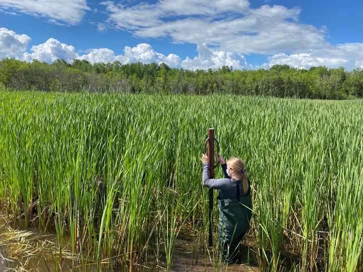
Figure 5: An emergent St. Louis River Estuary wetland in the summer.

Three common characteristics are frequently used to define these freshwater systems: 1) a drowned river mouth; 2) a zone where lake and river waters mix; and 3) influence from seiche or wind tides. A fourth characteristic that some, but not all, freshwater estuaries have is a bar or spit that can partially and/or periodically enclose the river mouth.

Freshwater Estuary: 1) Drowned River Mouth

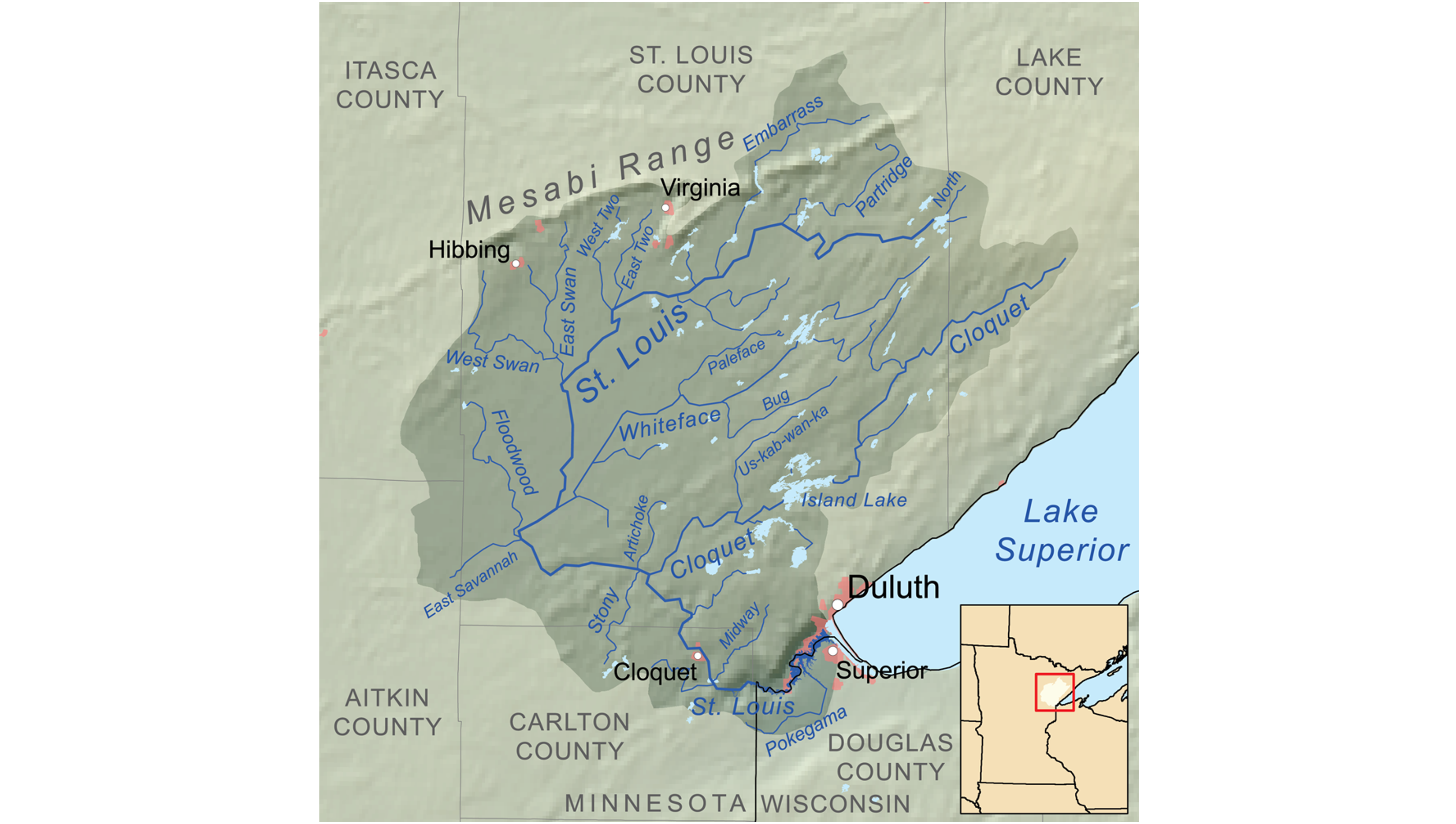
The St. Louis River Estuary is a drowned river mouth, a river mouth (the end of a river where it enters another water body, such as one of the Great Lakes) that becomes submerged or flooded. At the end of the most recent Ice Age, massive amounts of ice up to several hundred feet thick retreated from much of the Great Lakes Basin. As the ice retreated, the earth’s crust, which had been pushed down by the weight of the ice, started to very slowly rebound. The rebounding of the earth’s crust is still occurring today. Post-glacial rebound, also known as isostatic rebound, is occurring more rapidly along the northeastern and eastern portions of Lake Superior causing uplift in the earth’s crust that “tilts” the Basin toward the southwest, thereby flooding lake water into river mouths along the south-western shore, creating drowned river mouth systems. The drowned river mouth is an important characteristic of freshwater estuaries, providing specific habitat niches for a variety of plants, fish and wildlife.

According to a 1995 study by the United States Geological Survey titled, Rapid Submergence of Lake Superior Shorelines, the water levels in the southwestern portions of Lake Superior have risen approximately 15 to 18 feet over the past 2000 years. They estimate that the lake level rise in those areas is occurring at a rate of one inch per decade and that rising Lake Superior water levels associated with the rebounding of the earth’s crust will continue to flood low-lying river mouths and expand wetlands.

2011 satellite image of the St. Louis River Estuary's drowned river mouth.

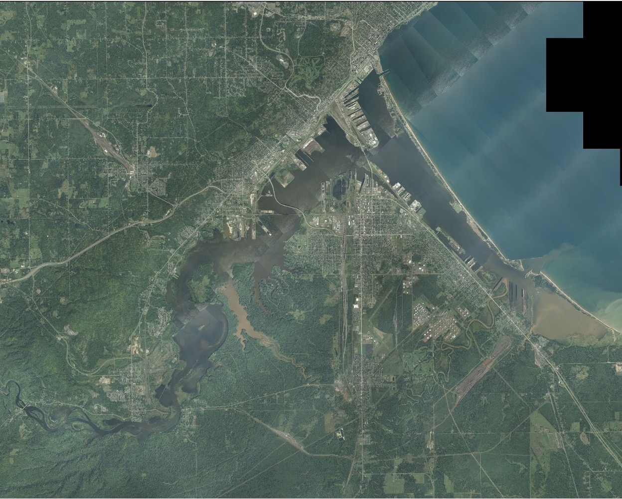
Figure 6: A satellite image of the drowned river mouth of the St. Louis River estuary taken in 2011.

Freshwater Estuary: 2) River-Lake Transition Zone

Freshwater estuaries, including the St. Louis River estuary, have a zone of transition, where river water meets and mixes with lake water. The mixing of water in this transition zone creates unique characteristics that influence important ecological processes. For example, stream water typically has a higher temperature and more suspended solids than Lake Superior. The mixing of river and lake water can affect water temperature, turbidity, and chemical composition, which influences water density, currents, and the transport of sediments, nutrients, and contaminants.

Freshwater Estuary: 3) Seiche and Wind Tides

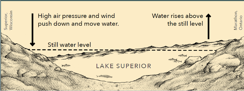
The Great Lakes exhibit an important natural phenomenon called a seiche. A seiche is an oscillation, or periodic back-and-forth movement of water, that occurs in large water bodies. One way to visualize a seiche is to imagine a bowl of water that is gently shaken. After shaking the bowl, the water continues to move back and forth. The same phenomenon happens in the Great Lakes, only the factors “shaking” the Great Lakes are atmospheric disturbances such as a change in barometric pressure. In water bodies as large as the Great Lakes, the back-and-forth movements are continuous and seiche effects can be observed on a daily basis. The intervals, or periods, between seiche peaks on the Great Lakes can range from minutes to more than eight hours. Seiches cause changes in water surface elevations of a few inches to several feet depending upon atmospheric conditions and location. Freshwater estuaries experience frequent wet and dry periods, especially near the water margins, due to seiche effects. A wind tide, or storm surge, is a vertical rise in water level on the leeward, or downwind, side of a water body as a result of strong winds. Storm surges on the Great Lakes can produce a change in water level of up to eight feet under extreme conditions. Given their association with storms and high winds, the effects of a wind tide are often more dramatic than the effects of a seiche. Wind tides can also be a contributing factor to seiche effects.

Seiche and wind tides illustration

Figure 7: An illustration depicting the seiche on Lake Superior.

Seiche and wind tides are important to freshwater estuaries because the water level fluctuations they produce are key to maintaining the diversity of habitats found within the freshwater estuary, as well as providing a means of mixing water and nutrients. When a seiche causes intrusion of lake water into a river, it causes opposing flow between unidirectional river current (moving horizontally) and oscillating lake current (moving vertically).iii The seiche causes an exchange of water between the lake and the river, and contributes to stratification within the river as colder lake water flows beneath warmer (and therefore, less dense) river water.

Freshwater Estuary: 4) Baymouth Bars and Barrier Spits

Freshwater estuaries are commonly separated from the adjacent main body of water by a baymouth bar or barrier spit. Spits and bars are accumulations of sand and gravel that can form entirely or partly across the mouth of a river. Many, although not all, freshwater estuaries are partially or periodically enclosed by bars or spits. The lakeward side of baymouth bars is typically composed primarily of sand, while the landward side consists of finer sediments. Baymouth bars can shelter the freshwater estuary from the high-energy wind and waves of the Great Lakes and influence the mixing of lake and river water.

Excerpt from the Lower St. Louis River Habitat Plan:

The Lower St. Louis River flows through thick layers of red clay that were deposited approximately 11,000 years ago as the Superior Lobe of the Laurentide Ice Sheet retreated (Farrand and Drexler 1985). After the level of ancestral Lake Superior dropped, the river and its tributaries cut deeply incised valleys through the easily eroded clay. When the lake level rose again, the river valley was flooded, creating a complex estuary with an irregular shoreline and bays at the mouth of each tributary. The ongoing, gradual rebound of the earth’s crust faster to the east and north is causing the water level to continue rising slowly within the estuary.

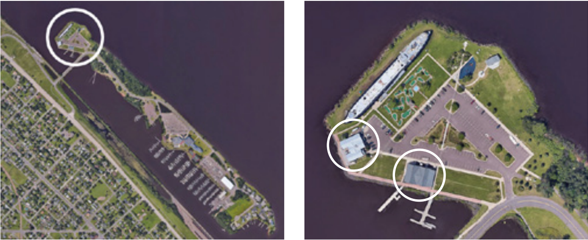
The baymouth bar that protects the waters of the Duluth-Superior Harbor is typical of freshwater estuary systems. The lakeward side of the bar is composed primarily of sand, and the landward side consists of finer sediments. The baymouth bar as a whole shelters the harbor from the high-energy wind and waves of Lake Superior, allowing wetland habitats to develop. Remnants of at least two older baymouth bars that formed during earlier periods of higher lake levels are found within the estuary. Grassy Point, located about 8 miles upstream from the mouth of the St. Louis River, represents a baymouth bar from an earlier glacial lake stage when the water level was at least 3 feet higher than the current level. Approximately 5 miles upstream from the mouth of the St. Louis River is Rice’s Point (Minnesota)/Connors Point (Wisconsin), another remnant baymouth bar.

Image of the St. Louis River Estuary Baymouth

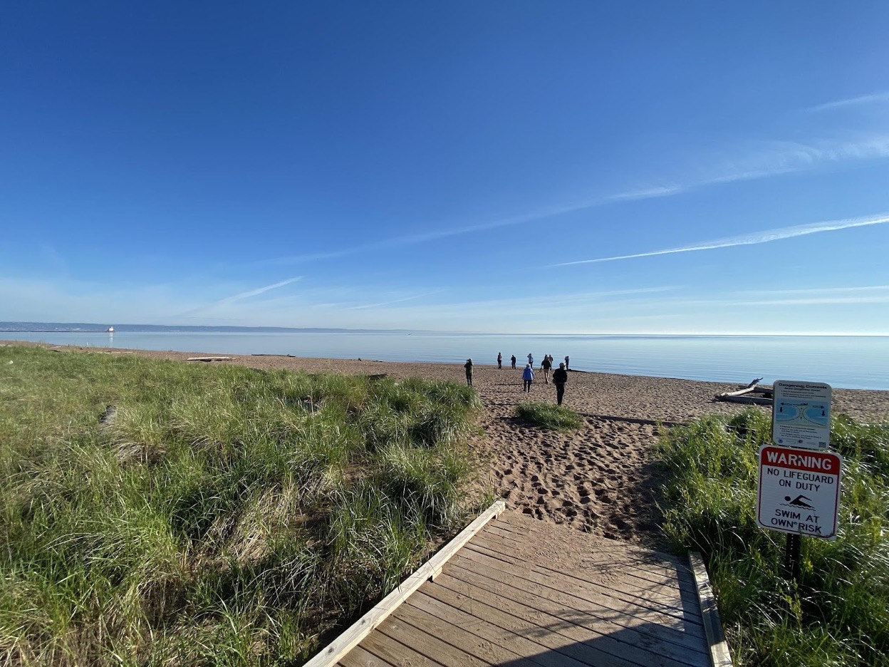
Figure 8: A birding group explores Wisconsin Point, one of the baymouth bars that form the St. Louis River Estuary.

Back to Top

II. Estuarine Habitats

The interactive map below can be used to investigate the habitat and authoritative boundaries maintained within the Lake Superior National Estuarine Research Reserve. Use the map controls to zoom in and out of research locations, turn on layers and explore. For more information on existing areas of research check out the Research and Monitoring Chapter of the Site Profile.

Back to Top

III. Ecological Significance

The Lower St. Louis River is one of the largest and most important freshwater estuary systems. In spite of legacy impacts, the Lower St. Louis River ecosystem is both regionally and globally significant. Great Lakes wetland systems are unique from a global perspective, and the St. Louis River Freshwater Estuary is one of the largest such complexes on the Lake Superior shore, represent-ing a significant source of productivity for the entire Lake Superior ecosystem.

The combination of ecosystems within the Lower St. Louis River—estuarine wetlands and aquatic habitats, baymouth bar complex, and surrounding upland forest—are very unusual in Lake Superior, the Upper Midwest, and the wider Great Lakes region. Many of the ecosystems and native species are rare and/or declining across their range. This concentration of such diverse ecosystems, along with its location on the western end of Lake Superior, makes this freshwater estuary a critical migratory stopover and an important breeding area for many species.

Two ecological processes—lake level fluctuations and river flow—in combination with the morphology of the estuary, are the main factors determining the nature and extent of the wetland and aquatic habitats in the estuary.

Further information on primary habitats, significant species, and archaeological sites within the proposed NERR boundary is given in the following sections. Sources for the following habitat descriptions include: the Wisconsin Wetland Inventoryxlvii, Lower St. Louis River Habitat Planxlviii, and the Wisconsin Initiative for Statewide Cooperation on Landscape Analysis and Data (WISCLAND).

Designated: 2010

Lead Agency: University of Wisconsin–Madison Division of Extension’s Natural Resources Institute

Protects: 16,697 acres

Located: Northwestern corner of Wisconsin along the St. Louis River, bordering Minnesota and Lake Superior

Biogeographic Region: Great Lakes

IV. Overview of Human Dimensions

Gichigami-ziibi (the great sea/lake river in Ojibwemowin) or the St. Louis River, is the traditional and current homeland of the Anishinaabe Ojibwe people and other Indigenous peoples before them. The region holds a central importance in Anishinaabe culture and spirituality, as well as historic and contemporary lifeways. Lands along the estuary were ceded via treaty agreements between the U.S. government and the Lake Superior Chippewa (or Ojibwe) in both 1842 and 1854. Ojibwe people have retained the rights to hunt, fish, and gather in traditional territory outside of the boundaries of reservation land and actively engage in those activities. Both the Fond du Lac Band of Lake Superior Chippewa and the Great Lakes Indian Fish and Wildlife Commission now conduct monitoring, research, and restoration work within the boundaries of the Reserve and within the estuary as well as Lake Superior.

A map depicting population density of Superior, WI by voting district.

Figure 9: A map depicting population density of Superior, WI by voting district. Black dots on the map indicate water access points identified in a community survey performed at the 2021 Lake Superior Day event on Barker's Island.

The Lake Superior Reserve is situated in Superior, Wisconsin, and adjacent to Duluth, Minnesota. Together the Twin Ports have become regional retail and service centers in the Lake Superior region. Tourism and recreation drive the Great Lakes economy in the Twin Ports, with some 6.7 million tourists visiting each year, drawn in large part by the beauty and natural amenities of the St. Louis River and Lake Superior. Multiple universities and colleges in the region, a large industrial port, two large medical facilities, energy and trade, as well as education and health services, contribute significantly to the overall coastal regional economy.

Back to Top